.png.5ff10cca1d0967e44a17e4a2edde2a80.png)


AdnamsGirl
-
Posts
759 -
Joined
-
Last visited
-
Days Won
7
Content Type
Profiles
Forums
Events
Articles
Posts posted by AdnamsGirl
-
-
Found him
GEORGE HENRY SLAUGHTER 1937 The Eagle Tavern Neatishead
II think I'd got there on page four of this thread in March 2010 ... do keep up FTM !


Carol
-
 2
2
-
-
Oh behave you lovely lot ... you're making me blush!

It's really lovely to know that people appreciate Broadland Memories so much but I certainly don't do any of it for reward or awards. The fact that I've been given access to so much fantastic history of the area, and been given permission to put it out there for others to share, rather than having it tucked away in people's lofts, and that others find it of interest is all the reward I need.

I'd feel hugely embarrassed about accepting an award for what I do as it's just a labour of love. Besides which ... it might mean having to have my photo taken!

But thank you all so much!
Carol
P.S. Many thanks for your kind words about the DVD ... your copy will be in the post this morning Pauline!
-
8
-
-
Ooops ... don't know how I managed to post this twice. My apologies ... it's been one of those days!
-
1
-
-
Just discovered this wonderful timelapse footage from Hunters yard. Getting Hustler 4 out of the water and into the shed at the end of the season the traditional way.
http://www.jfranks.co.uk/2014/09/10/2013-hustler-4-comes-into-the-shed/
Carol
-
Just discovered this wonderful timelapse footage from Hunters yard. Getting Hustler 4 out of the water and into the shed at the end of the season the traditional way.
http://www.jfranks.co.uk/2014/09/10/2013-hustler-4-comes-into-the-shed/
-
2
-
-
It was Norwich according to British Pathe in 1934
-
1
-
-
Thanks Paul & Liz
Seems shocking that they were demolishing cottages like that as late as the 1980s. I have checked it out in Street View and will hopefully be over there with my camera in a couple of weeks to get some "now" shots. Street View is a brilliant tool when trying to find locations in old postcards! It saves me wandering backwards and forwards aimlessly when I go to try and do my Then & Now's.
The first postcard of the boatsehd, I now think may be The Score which runs down to the river from the southern end of Northgate, just off the Old Marketplace. I will find out in a couple of weeks!
Carol
-
Thanks Peter. I wonder where the hell I got it as being near Beccles from then!
Great to see some photos of the Dutch Tea Gardens in that link.
Carol
-
If anyone would have a photo of a particular pub then I knew it would be Howard!
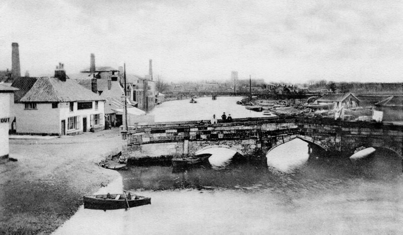
This is an interesting photo which dates from around 1907 and was taken from the church tower in Beccles. It shows the view across the town and looking downstream on the River Waveney. That's the rail bridge you can see with the old road bridge in the background.
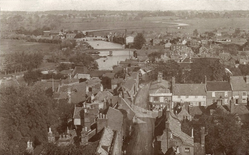 Aerial view of Beccles c1907 by AdnamsGirl, on Flickr
And this is the view from the old bridge looking upstream towards the rail bridge. It all looks a little different now.
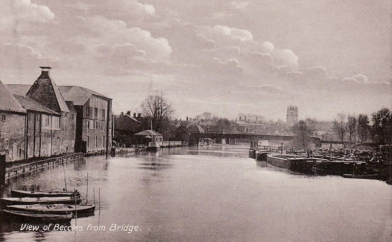 The River Waveney at Beccles c1910 by AdnamsGirl, on Flickr
Trading wherries on the River Waveney at Fisher Row near Beccles c1910
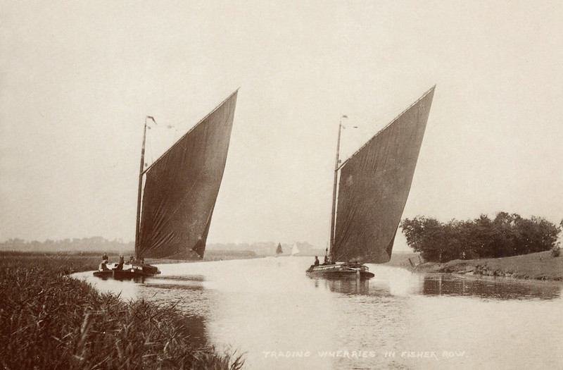 Trading wherries, Fisher Row, Beccles c1910 by AdnamsGirl, on Flickr
Carol
-
5
-
-
Hi Trevor - Strangely, no! I'm not sure I have ever come across a photo of the Loaves & Fishes. Pub photos are often a bit thin on the ground - I guess people are too eager to get to the bar for a beer!
Hi Alan - I have uploaded some of the Then & Now's I've done, including a few Beccles ones, to this thread:
I will link to a few more on there and will hopefully have some new ones to add soon!
Hi Howard - I don't really have much in the way of images of the railway other than more of the bridge crossing the Waveney there. Yes, it was part of the Beccles to Tivetshall line which did cross that bridge at Geldeston.
There is an interesting Flickr group/set which has some old images of the railway and "now" pics of the line and associated buildings too:
Carol
-
4
-
-
I uploaded a couple of "new" old photos of Beccles today which I thought some might be interested in.
This first image dates to around 1910 and shows and old boatshed, cottages and the River Waveney beyond. I'm looking at possible candidates for some new "Then & Now's" and think this must have been off Northgate. I certainly recognise the boatshed from old photos of the riverside taken from the rail bridge at Beccles but whether I'll be able to track down the exact location, and whether it will be accessible to take a modern comparison shot is another matter. A lovely, idyllic Broadland scene though.
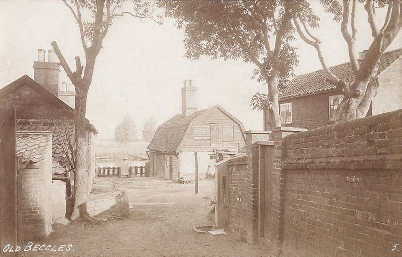 Riverside boatshed, Beccles c1910 by AdnamsGirl, on Flickr
Another image from the same c1910 series. This is Stepping Hill which links Puddingmoor to Ballygate. I think that these old cottages have gone, replaced by modern housing, but will check them out when I next get to Beccles.
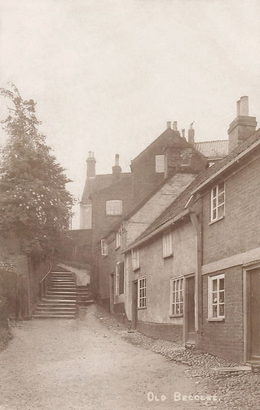 Stepping Hill, Beccles c1910 by AdnamsGirl, on Flickr
This is one which I uploaded a while ago and it's a rare image of the original three arched, stone bridge c1870s. It was demolished in 1880 and the new, cast iron road bridge erected in 1881. You can see the old rail bridge in the background too.
 The original Beccles Bridge c1870s by AdnamsGirl, on Flickr
Want some more?

Carol
-
5
-
-
Hi Strowager
I'm afraid this is the highest resolution copy I have of the image. As I said earlier, I didn't do the scan and can't remember where the image came from as it has been lurking on my PC for several years.
Carol
-
Great work Liz - both with the Roy Clarke pic and with finding one of the original Haddisoce rail bridge which is fascinating to see!
I've still not come up with any more pics, but Haddiscoe is looking increasingly likely isn't it? Here is thr full image flipped round the other way ... and looking again, I was mistaken about the chap with the rifle as he is right handed this way round.

-
3
-
-
I can't find any older photos of Somerleyton at the moment .. or Haddiscoe or Aldeby. I know I have a few later images of the Haddiscoe and Aldeby swing bridges but haven't had the chance to dig them out yet.
I've done a little more searching into the possibility of it being Haddiscoe. I found an article online by Mike Sparkes which makes mention of a Grimes Mill at Haddiscoe which was later replaced by a steam mill. It may well be that this is what was marked on Bryants 1826 map as Grimmers Mill. This was marked as being in the right location to fit the buildings in my photo if the image has been reversed.
http://www.sailing-by.org.uk/content/passage-yarmouth
That's quite an interesting article anyway

The Broads Authority Character Assessment for the River Waveney between Norton Marshes and the dismantled railway mentions that there were several lost drainage mill sites within the area including at least three steam mills.
It seems possible that there would have been a steam mill on that spot which would explain the chimney in the original photo if it has been reversed.
My only reservations about the image having been flipped is the chap with the gun, who now appears to be left handed. It's perfectly possible of course that he was left handed, but statistically more likely that he was right handed.
Or maybe that's why the photo was scanned the wrong way ... because it was presumed he was right handed?
Who knows! I can't work out any other way to tell whether the image had been reversed.
-
A quickie as I'm a bit tied up today, but I had a look at the late 19thC and the 1901 ordnance survey maps and there does appear to be a small range of buildings marked in that area. No mention of there being any sort of mill, but the chimney could be industrial rather than steam mill related. Bryants 1826 map shows a mill standing in that spot, marked as being "Grimmers Mill". I haven't been able to find out any more about this.
I've attached a photo which does, and doesn't help! This is a still from my 1930s cine footage which shows the Haddiscoe lifting bridge, looking back towards the rail bridge which you can just about make out in the background. What it does show is a small glimpse of buildings on the right hand side, between the two bridges. Unfortunately, there is not enough seen to be able to confirm whether they were the same buildings, but evidence at least that there were some in the right area.

-
1
-
-
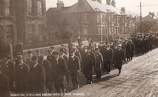
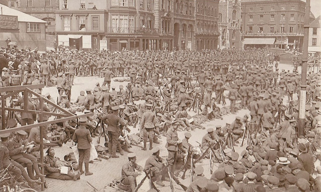
Another one from Norwich, this time relating to defending the home front. This is captioned as being the Norwich Civilians Emergency Corps Parade and would probably also be c1914. This was actually identified for me as having been taken on the Aylsham Road and there was certainly a good turn out. I guess this was the Dad's Army of the Great War, and was one of a number of groups set up to defend Britain in the event of invasion.
 Norwich Civilian Emergency Corps Parade c1914 by AdnamsGirl, on Flickr
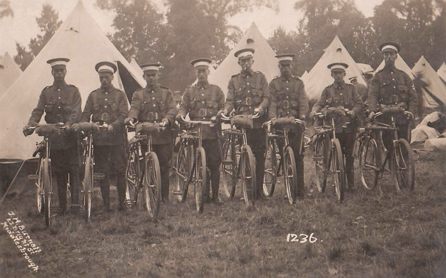
The threat of invasion meant that the Norfolk coast was considered a prime target due to it's close proximity to Europe. Some of the pillboxes erected during the great war can still be found on the coast and also inland - there's one at Wayford Bridge. The coast was also defended by the 6th Battalion Norfolk Cyclists
 Norfolk Regiment Cyclists c1914 WW1 by AdnamsGirl, on Flickr
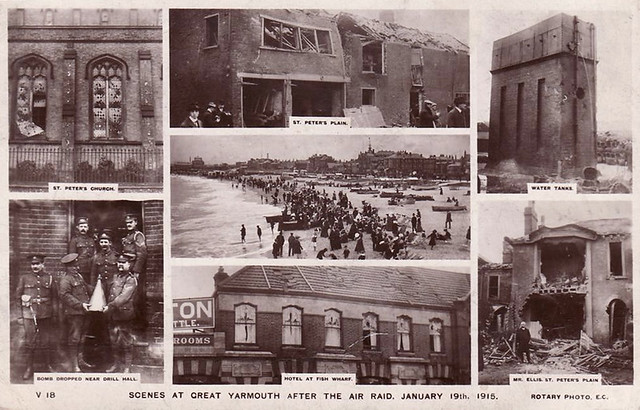
Early in 1915, a new threat to the home front came from the skies. The zeppelin. On the morning of the 18th January 1915 three zeppelins, the L-3, L-4 and L-6, were launched from their base in Germany and began the long flight to Britain, armed with explosive bombs and incendiary devices. The L-6 encountered problems soon into its flight and had to return to base, leaving the L-3 and the L-4 to continue their mission alone. Their initial target had apparently been the dockyards of the Humber Estuary, but a combination of bad weather and poor navigational aids saw the airships being blown off course and encountering the coastline of Norfolk instead. The L-3 had arrived at Great Yarmouth and, considering it to be a legitimate target, began dropping its payload over the town. It is reported that the first bomb was dropped over the marshes near Ormesby, but at 8.20pm the second bomb heralded the start of the raid on Great Yarmouth as the L-3 made a steady course across the town from north to south.
Eight bombs were dropped in total, three of which failed to detonate, one landed at the Fish Wharf, and another on St. Peter’s Plain where there was a scene of utter devastation. Many buildings were heavily damaged and two people lost their lives here – 72 year old spinster Martha Taylor and 53 year old shoemaker Sam Smith. This was the very first air raid on Britain and it heralded a new era of warfare.
It seems slightly macabre now, but in 1915 it was common to produce postcards showing disasters, death and destruction. I don't think newspapers tended to carry much in the way of images back then so it was a way for the public the see what had happened. We get 24 hour news channels now. These are a few of the postcards produced which showed the aftermath of the 1915 Zeppelin raid on Great Yarmouth.
 Aftermath of the first Zeppelin air raid on Great Yarmouth 1915 by AdnamsGirl, on Flickr
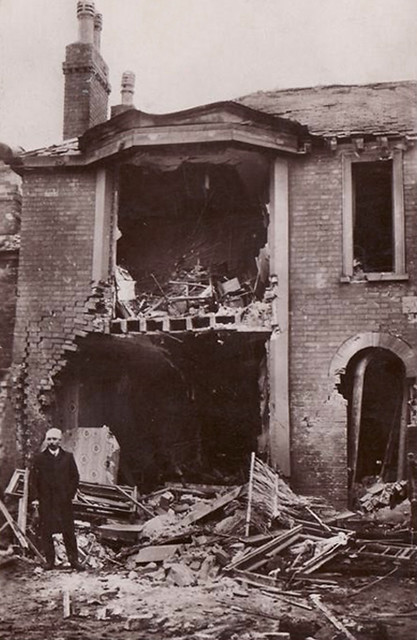
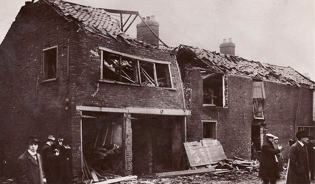 Zeppelin bomb damage at Great Yarmouth 1915 by AdnamsGirl, on Flickr
The caption for the next image read "Mr Ellis wounded by a bomb and his ruined house at Lancaster Corner, St Peters Plain."
 Zeppelin air raid damage at Great Yarmouth 1915 - 02 by AdnamsGirl, on Flickr
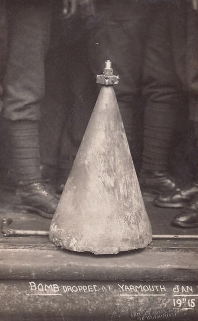 Zeppelin bomb dropped on Great Yarmouth 1915 by AdnamsGirl, on Flickr
-
2
-
-
We visited the Museum of the Broads at Stalham over the weekend as we hadn't been for a couple of years and I know they do change displays around and add new exhibits regularly. This year they have an exhibition about the Norfolk Broads in WW1 which is absolutely fascinating. They have gathered together some incredible artifacts, memorabilia, photos and information about the home front and local lads who were sent overseas. It's on until the end of the season and will apparently be repeated in 2018, but if you get the chance to visit this year then it's well worth a look ... as is the rest of the museum!
I have a few images relating to Broadland during the First World War, but not a lot. Here are a few:
I believe that a number of boatyards built craft for the Admiralty during the war. This postcard shows an armed launch built by Leo Robinson at Oulton Broad c1915. Built specifically for inland waterways, this launch is fitted with a Vickers machine gun
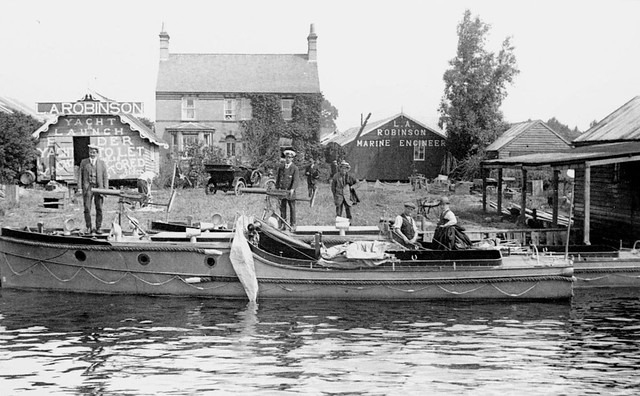 WW1 Armed Launch at Oulton Broad by AdnamsGirl, on Flickr
There were a number of military hospitals set up around Broadland during the war to look after injured and sick troops being sent back to the UK from the front line. Some were set up in large, private houses such as the Voluntary Aid Detachment Auxiliary Hospital at Brundall House. I've an interesting set of images from Brundall House during WW1 featuring nurses and patients. The patients were issued with blue flannel uniforms, supposedly to make them easily identifiable so they wouldn't be able to head off to the pub which was out of bounds! Various activities were organised to help the men recuperate and recover and the next three photos show day trips for the staff and patients on the River Yare at Brundall.
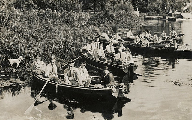 Brundall House WW1 Hospital rowing boats by AdnamsGirl, on Flickr
 Brundall House VAD Hospital rowing on the River Yare WW1 by AdnamsGirl, on Flickr
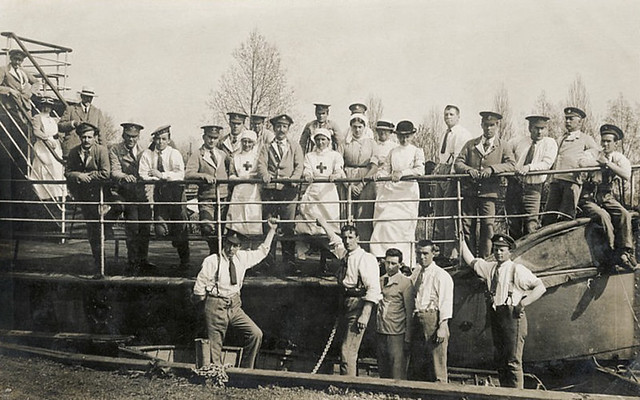 Brundall House WW1 hospital boat trip by AdnamsGirl, on Flickr
You get some sense of the sheer numbers of men sent overseas to fight in this next postcard which shows men of the Essex Regiment on Norwich Market Place c1914. Statistically, one in ten of these men never made it home.
 WW1 Soldiers, Norwich Market Place 1914 by AdnamsGirl, on Flickr
More later if anyone is interested.
Carol
-
7
-
-
I think the jury does remain out at the moment. I am still sort of erring towards Reedham, but am not entirely convinced and will keep looking for photos of the other bridges in the hope of finding something that matches.
-
There are more photos & postcards from the 1912 flood in a blog post I did on the anniversary last year: http://www.broadlandmemories.co.uk/blog/2012/08/1912-floods-photo-gallery/
Also more of the postcards showing the aftermath of the flood in Norwich in 1912 in the Norwich Postcards section of the Broadland memories website: http://www.broadlandmemories.co.uk/page109.html
Carol
-
2
-
-
Sorry for the delay in responding further but I've not had the chance to look into this any further yet.
Peter - I think I have an old AOL email address for Jamie Campbell but don't know whether that is still active. Please feel free to pass on the photo or post it elsewhere.
Unfortunately, I do not have the original negatives so cannot scan it to get a better resolution. To be honest, these have been lurking in the depths of my computer for so long, I can't remember where they came from either! They may well have just been up for sale on Ebay at some point.
I haven't managed to find any really old photos of the Haddiscoe or Somerleyton rail bridges yet & don't really know enough of the history of the Haddiscoe rail line to know when bridges, buildings etc. may have been replaced. I think that Somerleyton bridge was replaced along with the Reedham Bridge c1905. A quick Google brings up mention that the original Haddiscoe station was closed in 1904 in favour of using the High Level Station where the signal box we know stands today. Could it be possible that the current signal box was not built until that time as it is likely that my photo could predate that. As has been said, there is always a possibility that the negative was scanned in reverse (thanks for flipping it Strowager) ... or that it may not actually be the Broads. Flipping the photo does make the chappie with the gun left handed though. The mystery Pylon like structure in the background is odd. A mill of some sort perhaps? It looks too uniform a shape to put down to be a bit of muck or damage on the original negative, but that is always a possibility too I suppose.
-
Hi Bill
I will have a look to see whether I can find any photos of Somerleyton contemporary to my picture when I get the chance to see whether there were any similar looking buildings in that area.
Many thanks!
-
I don't think it was taken at the Sandersons end of Reedham as you would have seen Halls boatyard and many of the riverside buildings & quay on the left and the hill in the village. It would have to have been taken from the other side of the bridge, looking upstream, to be Reedham.
I'm pretty certain that the other glass negs in the set were all taken on the Broads. The party were at Yarmouth and I think a couple of other shots are southern rivers. If it is Reedham then the land on the left is marshland and Reedham village would be on the right hand side. There isn't enough of the right hand bank to see enough to be certain and I'm still trying to locate more photos of Benns' farm & steam pump to compare what I can see in my pic. I don't know how much there was at the far end of Reedham at the turn of the century.
Thanks for all your input! I do love a mystery, but this one is driving me slightly nuts.

-
2
-
-
Hi Bill - I'm not sure whether Somerleyton works because of that range of buildings and the chimney you can see in the original photo. I don't think there was ever anything like that at Somerleyton?
Hi Alan - by the crane, do you mean the one near Sandersons yard?
There are a couple of interesting pics within the counsil archives on the Picture Norfolk website. I am not sure whether these help or not. They certainly show some buildings and a steam pump chimney opposite the junction of the Yare and the New Cut, but are the buildings right? It's hard to tell and buildings could have been added of course. I suspect the Picture Norfolk photos are going to date to the 1880s/90s so maybe 10 or 20 years older than mine.
https://norfolk.spydus.co.uk/cgi-bin/spydus.exe/FULL/OPAC/BIBENQ/58583030/2211184,1?FMT=IMG&IMGNUM=1
https://norfolk.spydus.co.uk/cgi-bin/spydus.exe/FULL/OPAC/BIBENQ/58583113/2211110,2?FMT=IMG
-
If the boat in my photo was actually moored round the corner from the bridge, on the end of Haddiscoe Island (X marks the spot below) then I think that might work given the marked position of the pumping station? It's a difficult one to call without seeing more images of the buildings that were at Reedham. Further investigation needed I think.


Boat of the Seventies?
in The Historic Broads
Posted
It does look like Broadheart. Here is the 1976 Blakes brochure entry for Broadheart.
Carol